DeepFeatures
About
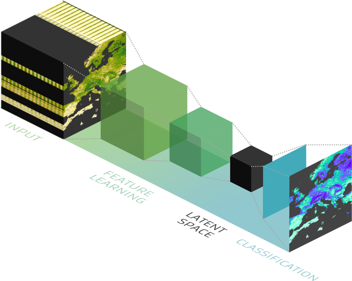
Although spectral indices (SIs) represent specific enhanced properties of the Earth’s system dynamics, there is no holistic, data driven approach that combines them. Studies typically focus on a few SIs out of more than two hundred. Our AI approach synthesises and optimises these SIs by using AI dimension reduction to reduce the number variables required to describe the dynamics of the underlying system. At the same time critical and representative latent structures (not directly observable) are extracted and the Feature Data Cube is created. As a result, the Feature Data Cube lowers computational cost for further data exploration and is applicable to a range of applications.
The project is funded by the European Space Agency (ESA), part of the AI4SCIENCE activity. The second AI4SCIENCE ITT focuses on the use of AI/ML in the EO domain to unlock the potential offered by novel hetereogenius multi-variate datasets to better characterise, simulate and predict the behaviours of key components of the Earth system and its interactions with human activities and ecoystems.
Data
- Sentinel-2
- Awesome Spectral Indices
Team
- Miguel Mahecha (Leipzig University, Germany)
- Karin Mora (Leipzig University, Germany)
- Martin Reinhardt (Leipzig University, Germany)
- Gunnar Brandt (Brockmann Consult GmbH, Germany)
- Tejas Morbagalharish (Brockmann Consult GmbH, Germany)
- Chaonan Ji (Leipzig University, Germany)
- Guido Kraemer (Leipzig University, Germany)
- Teja Kattenborn (Leipzig University, Germany)
- Clemens Mosig (Leipzig University, Germany)
- Francesco Martinuzzi (Leipzig University, Germany)