PARSe Biodiversity
Team
- Dr. Swapna Mahanand (Biodiversity & Remote Sensing, Postdoc)
- Prof. Dr. Hannes Feilhauer (Ecology & Remote Sensing, PI)
- Prof. Dr. Christopher Pöhlker (Atmospheric Chemistry, CO-PI)
- Prof. Dr. Mira Pöhlker (Atmospheric Chemistry, CO-PI)
- Prof. Dr. Bettina Weber (Vegetation Science, Co-PI)
- Prof. Dr. Ingolf Kühn (Geospatial Statistics, Co-PI)
Projet Outline
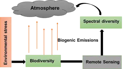
In PARSe Biodiversity, we study the influence of plant diversity on emissions of volatile organic compounds (VOCs) and greenhouse gases that are released into the atmosphere. These emissions are specific to each plant species and can be influenced by plant stress caused by extreme events, such as droughts. Our goal is to investigate the buffering effects of plant species richness and functional diversity on these emissions, as well as the feedback loops involved.
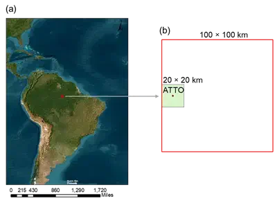
To achieve this, we employ a combination of remote sensing, atmospheric measurements, vegetation data, and spatial statistics. We conduct our research at the Amazon Tall Tower Observatory (ATTO), using pixel-to-pixel variation in satellite imagery as an indicator of above-ground functional diversity. This indicator is tested against pre-existing and newly sampled survey data to map diversity in the tower’s surroundings.
By analyzing wind directions, we identify the source regions of gases and particles measured at the tower and study the links to diversity patterns. Through our research, we aim to fill the current knowledge gap in this area and provide insights into the effects of biodiversity on the environment.
Research Questions
-
Which spectral biodiversity indicators show the best agreement with the diversity patterns assessed from vegetation surveys in the Amazon Forest of the study area?
-
Does biodiversity buffer the effects of extreme weather conditions on gas and particle emission? Do forests with a high level of species richness and functional leaf and canopy trait diversity feature fewer emissions under variable weather conditions than forests with lower diversity?
Research Collaborators
- Remote Sensing Centre for Earth System Research (RSC4Earth)
- German Centre for Integrative Biodiversity Research (iDiv)
- University of Leipzig (UL)
- Max Planck Institute for Chemistry (MPI)
- Helmholtz Center for Environmental Research - UFZ (Helmholtz-Zentrum für Umweltforschung GmbH - UFZ)
- Martin-Luther University Halle-Wittenberg
- University of Graz, Austria
Funding Source
The project is funded by iDiv through Flex pool project fund