Unmanned Aerial Vehicle-Based Mapping of Turf-Banked Solifluction Lobe Movement and Its Relation to Material, Geomorphometric, Thermal and Vegetation Properties
Abstract
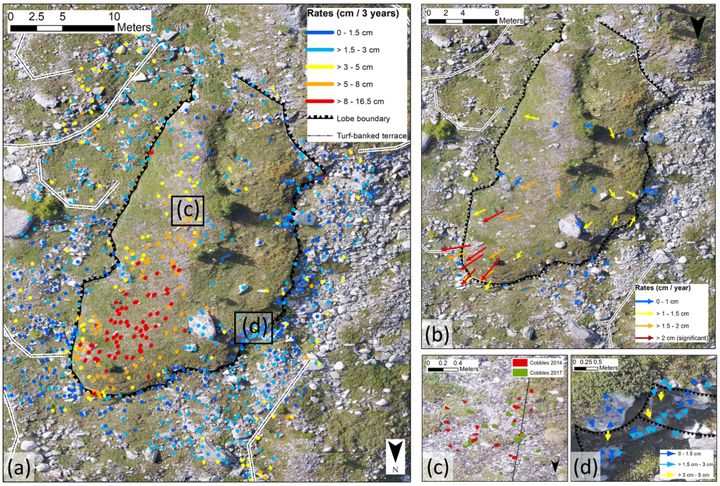
Solifluction is one of the most widespread periglacial processes with low annual movement rates in the range of millimeters to centimeters. Traditional methods to assess solifluction movement usually have low spatial resolution, which hampers our understanding of spatial movement patterns and the factors controlling them. In this study, we (a) test the applicability of unmanned aerial vehicle (UAV)-based structure-from-motion photogrammetry in comparison to a traditional total station survey to map surface movement of a turf-banked solifluction lobe (TBL) in the Turtmann Valley (Switzerland). We then (b) relate the detected movement patterns to potential geomorphometric, material, thermal and vegetation controls, which we assessed using geomorphic and vegetation mapping, electrical resistivity surveys and temperature loggers. Our results show that (a) UAV-based mapping can detect solifluction movement with high spatial resolution (one point per m2, total $>$ 900 points) and rates and patterns consistent with a total station survey, but requires careful measurement set-up and analysis; and (b) movement rates differ between lobe tread, riser and a ridge feature. Differences can be explained by heterogeneous material, geomorphometric, thermal and vegetation properties of the TBL, which promote different solifluction processes. Our study demonstrates the applicability of UAV-based mapping in solifluction research and improves our understanding of solifluction processes and landform development.